


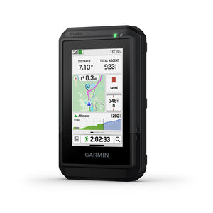
Garmin eTrex® Touch GPS Handheld Navigator – Outdoor Navigation, Mapping & Tracking
Rugged 3″ touchscreen GPS handheld with preloaded TopoActive maps, multi-band GNSS + SatIQ, up to 130 hours battery life (650 hours Expedition mode), IP67 water rating, Wi-Fi map downloads, and Garmin Explore app compatibility.
Our Take: The eTrex Touch is the handheld GPS that Garmin's hiking community has been asking for — a proper color touchscreen with real TopoActive maps, multi-band GNSS accuracy, and battery life that outlasts multi-day trips. At 5.3 oz with a 3″ display you can actually swipe and zoom, it hits the sweet spot between the stripped-down eTrex Solar and the heavier GPSMAP flagships. It doesn't have satellite messaging or SOS — this is purely a navigation device — but for trail hikers, bikepackers, geocachers, and anyone who wants reliable GPS without phone dependency, it's hard to beat for the price.
Why you'd choose the eTrex® Touch
-
High-resolution color TFT display (240 × 400 px) with tap, swipe, and pinch-to-zoom for quick map interaction. Glove-friendly and readable in direct sunlight — a major upgrade from button-only handhelds.
-
Maps for the U.S., Canada, and Mexico load out of the box with terrain contours, elevations, summits, rivers, lakes, coastlines, and points of interest. Optional Outdoor Maps+ subscription adds satellite imagery and land boundaries.
-
Accesses multiple satellite constellations on dual frequencies for better accuracy under dense canopy, in steep canyons, and in urban environments. SatIQ automatically balances accuracy and battery draw so you don't have to choose.
-
Up to 130 hours in per-second, all-satellite multi-band mode with SatIQ. Switch to Expedition mode for up to 650 hours (27 days) with reduced tracking frequency — ideal for thru-hikes and extended backcountry trips.
-
Popularity routing suggests well-traveled trails based on aggregated user data. Round-trip routing creates loops of your specified distance that return you to your start. Ascent planning previews upcoming climbs and gradients.
-
Download map updates and Outdoor Maps+ premium content directly to the device over Wi-Fi — no computer or cable needed. Keep your maps current without extra steps.
-
Built-in geocaching features with cache descriptions, logs, and hints. Pair with a smartphone for Geocaching Live updates. Caches sync to your Geocaching.com profile automatically.
-
At 150 g (5.3 oz) and 2.6″ × 4.15″ × 0.97″, it fits in a cargo pocket or clips to a pack strap. IP67 rating means full protection from dust and submersion in 1 meter of water for 30 minutes. 32 GB internal storage. USB-C charging.
Who this handheld is ideal for
- Day hikers and backpackers who want reliable trail navigation without draining their phone battery.
- Bikepackers and cycle tourists who need a handlebar-mounted GPS with real maps and multi-day battery life.
- Geocachers who want live cache updates and a proper touchscreen for map interaction.
- Hunters and anglers who need preloaded topo maps with optional premium layers (land boundaries, wildlife areas).
You may prefer a different Garmin handheld if…
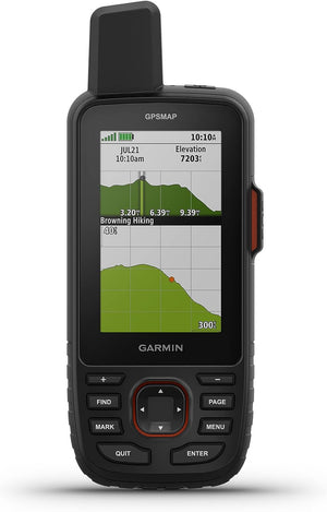
- You need satellite messaging + SOS — the GPSMAP 67i ($599.99) adds inReach two-way messaging, location sharing, and interactive SOS via the Iridium network.
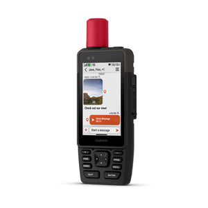
- You want the most advanced handheld with camera and voice messaging — the GPSMAP H1i Plus ($999.99) adds inReach Plus with photo/voice memo sharing, a 3.5″ touchscreen + button controls, and a built-in camera.
- You want a premium navigation-only handheld with a larger 3.5″ screen — the GPSMAP H1 ($699.99) offers the same flagship build without inReach.
- You need a button-only handheld with military-grade toughness and ABC sensors — the GPSMAP 67i's button interface works better with heavy gloves and in extreme cold.
Garmin eTrex® Touch Specifications
| Display | 3″ transflective color TFT touchscreen |
|---|---|
| Display Resolution | 240 × 400 pixels |
| Display Size | 1.53″ × 2.55″ (3.88 × 6.48 cm); 3″ diagonal |
| Input | Touchscreen (tap, swipe, zoom) |
| Dimensions | 66 × 105.4 × 24.6 mm (2.6″ × 4.15″ × 0.97″) |
| Weight | 150 g (5.3 oz) |
| Water Rating | IP67 |
| Maps | Preloaded TopoActive (U.S., Canada, Mexico); Outdoor Maps+ optional |
| GNSS | Multi-band (GPS, Galileo, QZSS + more) with SatIQ |
| ABC Sensors | Altimeter, Barometer, Compass |
| Satellite Messaging / SOS | No (navigation only) |
| LED Flashlight | No |
| Camera | No |
| Wi-Fi | Yes (map downloads) |
| Geocaching | Yes — with Geocaching Live support |
| Garmin Explore | Yes (app + website) |
| Battery (Multi-Band) | Up to 130 hours (SatIQ) |
| Battery (Expedition) | Up to 650 hours |
| Battery Type | Rechargeable internal lithium-ion |
| Storage | 32 GB (user space varies) |
| Interface | USB-C |
| Connectivity | Bluetooth, ANT+, Wi-Fi |
| Mount | Spine Mount 2 compatible |
| MSRP | $449.99 |
| MPN | 010-02940-00 |
| UPC | 753759346836 |
How the eTrex Touch Compares
Focus or hover a row label for a plain-English definition.
| Feature |
eTrex TouchThis Unit
|
GPSMAP 67iinReach
|
GPSMAP H1Nav Only
|
H1i PlusinReach+
|
|---|---|---|---|---|
| DisplayiScreen size and type — larger screens are easier to read but add weight and size. | 3″ TFT touch | 3″ color (buttons) | 3.5″ color touch + buttons | 3.5″ color touch + buttons |
| ResolutioniPixel count — higher resolution means sharper map details. | 240 × 400 | 240 × 400 | 282 × 470 | 282 × 470 |
| TouchscreeniWhether the device has a touchscreen for tap, swipe, and zoom map interaction. | ✔ | ✘ | ✔ | ✔ |
| Physical ButtonsiDedicated hardware buttons for glove use and cold-weather operation. | ✘ | ✔ | ✔ | ✔ |
| Multi-Band GNSSiAccesses multiple satellite frequencies for better accuracy under trees, in canyons, and near tall buildings. | ✔ | ✔ | ✔ | ✔ |
| SatIQiGarmin's smart satellite management — automatically toggles multi-band on/off to balance accuracy and battery life. | ✔ | ✘ | ✔ | ✔ |
| TopoActive MapsiPreloaded topographic maps showing trails, roads, contours, elevations, and points of interest. | ✔ | ✔ | ✔ | ✔ |
| Satellite ImageryiHigh-resolution photorealistic map overlays downloaded via Wi-Fi for terrain visualization. | Maps+ sub | ✔ (Wi-Fi) | ✔ (Wi-Fi) | ✔ (Wi-Fi) |
| ABC SensorsiAltimeter (elevation), Barometer (weather trends), and 3-axis electronic Compass for direction finding. | ✔ | ✔ | ✔ | ✔ |
| inReach MessagingiTwo-way satellite text messaging via the Iridium network — works anywhere on Earth, no cell coverage needed. Requires subscription. | ✘ | ✔ (text) | ✘ | Text + Photo + Voice |
| Interactive SOSiEmergency SOS button that sends your GPS coordinates to Garmin Response, a 24/7 staffed emergency coordination center. | ✘ | ✔ | ✘ | ✔ |
| Location SharingiShare your real-time GPS position via satellite so family and friends can track your progress on a map. | Garmin Share | ✔ (satellite) | Garmin Share | ✔ (satellite) |
| Built-In CameraiIntegrated camera for geotagging photos and sending images via satellite. | ✘ | ✘ | ✘ | ✔ |
| LED FlashlightiBuilt-in LED light for hands-free illumination and emergency signaling. | ✘ | ✔ | ✔ | ✔ |
| SireniAudible alarm for attracting attention or signaling in emergencies. | ✘ | ✘ | ✔ | ✔ |
| MIL-STD-810iU.S. military standard for thermal, shock, and vibration durability testing. | ✘ | ✔ | ✔ | ✔ |
| Water RatingiDust and water ingress protection level — IP67 means full dust protection and 1m submersion for 30 min. | IP67 | IPX7 | IP67 | IP67 |
| Battery (Tracking)iRuntime in the primary navigation mode with multi-band GNSS or standard tracking intervals. | 130 hrs (multi-band) | 165 hrs (10-min inReach) | 145 hrs (multi-band) | 145 hrs (multi-band) |
| Battery (Expedition)iExtended battery mode with reduced GPS tracking frequency for ultra-long trips. | 650 hrs | 425 hrs (inReach) / 840 hrs | 845 hrs | 845 hrs |
| StorageiInternal memory for maps, waypoints, tracks, and user data. MicroSD expands map capacity. | 32 GB | 16 GB + microSD | 64 GB + microSD | 64 GB + microSD |
| WeightiDevice weight — lighter is more comfortable on long hikes and easier to pocket. | 5.3 oz (150 g) | 8.9 oz (251 g) | 10.2 oz (290 g) | 10.2 oz (290 g) |
| Wi-FiiWireless connectivity for downloading maps and firmware updates directly to the device. | ✔ | ✔ | ✔ | ✔ |
| GeocachingiBuilt-in tools for finding and logging geocaches with live cache data updates. | ✔ (Live) | ✔ (Live) | ✔ | ✔ |
| MSRPiManufacturer's suggested retail price at launch. | $449.99 | $599.99 | $699.99 | $999.99 |
| Best ForiThe ideal use case and buyer profile for each handheld. | Hikers, bikepackers, and geocachers who want a lightweight touchscreen GPS with excellent maps and battery life — no satellite messaging needed. | Backcountry adventurers who need satellite SOS and two-way messaging alongside full GPS navigation. Button-only interface works in all conditions. | Serious navigators who want the largest screen and flagship hardware without paying for inReach. Premium build with flashlight and siren. | Off-grid professionals, expeditioners, and adventurers who need photo and voice satellite messaging, SOS, and the most advanced Garmin handheld available. |
Garmin eTrex® Touch — Frequently Asked Questions
What maps come preloaded on the eTrex Touch?
TopoActive maps for the U.S., Canada, and Mexico are preloaded and ready to use out of the box. Coverage includes roads, trails, terrain contours, topographic elevations, summits, rivers, lakes, coastlines, parks, and geographic points of interest. For additional detail like satellite imagery, land boundaries, and wildlife management areas, you can add an Outdoor Maps+ subscription (sold separately, starting at $4.99/month) and download content directly via Wi-Fi.
How long does the battery last?
Up to 130 hours in the primary navigation mode (all-satellite + multi-band with SatIQ technology, per-second tracking). When you switch to Expedition mode — which reduces GPS tracking frequency for ultra-long trips — the battery stretches to approximately 650 hours (about 27 days). Actual results depend on settings, screen brightness, and conditions. Charges via USB-C.
Does the eTrex Touch have inReach satellite messaging or SOS?
No. The eTrex Touch is a navigation-focused handheld without any satellite communication features. It cannot send or receive text messages via satellite and does not have an SOS button. If you need those capabilities, consider the GPSMAP 67i ($599.99) for inReach messaging and SOS, or the GPSMAP H1i Plus ($999.99) for inReach Plus with photo, voice, and text messaging.
Is the eTrex Touch waterproof?
It carries an IP67 rating: fully protected against dust ingress and can withstand submersion in up to 1 meter of fresh water for 30 minutes. That's plenty for rain, puddles, and accidental drops in shallow water. It is not designed for swimming or diving.
Can I use the eTrex Touch for geocaching?
Yes. The eTrex Touch has built-in geocaching tools including cache descriptions, logs, and hints. When paired with a compatible smartphone and the Garmin Explore app, it supports Geocaching Live updates so cache data stays current. Caches sync automatically to your Geocaching.com profile.
How does the eTrex Touch compare to the GPSMAP 67i?
The eTrex Touch ($449.99) is lighter at 5.3 oz, has a touchscreen, and focuses on navigation with exceptional battery life. The GPSMAP 67i ($599.99) adds inReach satellite messaging with SOS, button-only controls, MIL-STD-810 military durability, an LED flashlight, and a ballistics calculator. Choose the eTrex Touch for day hikes and trail navigation where you have cell coverage or don't need satellite messaging. Choose the 67i for remote backcountry trips where emergency communication is essential.
What is the difference between the GPSMAP H1 and H1i Plus?
Both the GPSMAP H1 ($699.99) and H1i Plus ($999.99) share the same 3.5″ touchscreen + button design, 64 GB storage, IP67 rating, MIL-STD-810 durability, LED flashlight, siren, and 145-hour battery life. The H1i Plus adds inReach Plus satellite technology — two-way text messaging, photo and voice memo sharing via satellite, interactive SOS, location sharing, and weather forecasts. The $300 difference buys satellite communication and a built-in camera.
Can I download maps over Wi-Fi?
Yes. The eTrex Touch supports direct-to-device map downloads over Wi-Fi. This includes firmware updates and optional Outdoor Maps+ premium content. No computer required — just connect to a Wi-Fi network and download directly on the device.
Does the eTrex Touch have an LED flashlight?
No. The eTrex Touch does not include a built-in LED flashlight. If a flashlight is important, the GPSMAP 67i, GPSMAP H1, and GPSMAP H1i Plus all include built-in LED flashlights that double as emergency beacons.
Can I mount the eTrex Touch on a bike handlebar?
Yes. The eTrex Touch is compatible with the Garmin Spine Mount 2 system, which supports handlebar mounts, cart mounts, and other accessories. It's popular with bikepackers and cycle tourists who need a dedicated GPS on the handlebars without draining their phone.
What's in the box?
The eTrex Touch package includes the GPS handheld navigator, a USB-C data/charging cable, and documentation. Mounts, cases, and other accessories are sold separately.
Need help deciding between the eTrex Touch, GPSMAP 67i, or GPSMAP H1 series? Call us at 1-800-403-8285 or 215-259-2700, or email sales@hrmusainc.com.